Click "Next" below to continue with the workshop.


Background

This process is about creating Concept and Community Plans for the 2,300 acre South Cooper Mountain area to the southwest of the city. This workshop builds on the previous phase of the project which focused on understanding the area's existing conditions and needs. The following exercises allow you to provide feedback on questions and issues that the team will use to develop options (or "scenarios") for how South Cooper Mountain might develop over time.

Using this site

Above are tabs that allow you to switch between exercises, or you can use the buttons below. You are welcome to respond to all questions, or only those questions that are of interest to you. The following exercises will take approximatley 20-30 minutes to complete:

  • Exercise 1 uses a map to organize various questions about land use. Click the icons to respond to questions.
  • Exercise 2 involves a series of open ended and multiple choice questions about transportation.
  • Exercise 3 allows you to drag icons across a map to describe how different types of development could be located within the South Cooper Mountain Annexation Area.

Before you begin, click "Next" below to tell us about you.

Technical issues or questions? Contact technical support or call (503) 235-5881 (JLA Public Involvment) for assistance during normal business hours.

Tell us about you...

What is your first name? (Required.)

What is your email address?
(If you would like to be added to the project mailing list.)

What is your primary connection to South Cooper Mountain?

Live/own in North Cooper Mountain
Live/own in the Urban Reserve Area
Live/own in the S. Cooper Mtn Annexation Area
Live/own near the Planning Area
None of the above - just care about the area

To begin, click the "Exercise 1" tab above, or "Next" below.

Exercise 1: Big Picture Land Use Concepts - A Step Toward Scenarios


Instructions: Click the icons on the following page to answer questions about each sub area. You do not need to answer questions about areas you are unfamiliar with. Click "Next" below to view the map.

Exercise 2: Transportation Issues and Ideas

Instructions: Review the background information on the following pages and answer the questions. Some questions may refer to maps or other handouts that you can open without leaving the workshop page. Click "Next" to continue.

Use the image controls or your mouse
wheel to pan and zoom the map,
or download the file: PDF, 1.6 MB

1. Top Transportation Issues and Priorities

Transportation has emerged as a top issue for citizens participating in the Concept Planning process to date.

In your opinion, what are the biggest transportation issues facing this area in the future? Which issues are your top priorities? (List below.)

Are there particular solutions or options to address these issues that you think should be considered? (Explain below.)

2. Bicycle and Pedestrian Facilities

The area has very limited bicycle and pedestrian facilities today. 175th Avenue, Grabhorn Road, Scholls Ferry Road and Tile Flat Road all lack accommodations for walking and biking. All new roadways within the planning area will be built to urban standards and will accommodate bikes and pedestrians. Retrofitting the existing roadways with sidewalks and/or bike lanes will be challenging in some locations, but these roadways provide important connections for pedestrians and bicyclists.

Thinking long-term, what will be the most important bicycle or pedestrian improvements that will need to be made in the Concept Planning area? (List below.)

3. Future Transit

Transit is not here now, but might be available over the next 20 to 50 years.  The Concept Planning area can be designed to be "transit ready" to facilitate transit service in the future.

Which of the following initial ideas make most sense to you to plan for future transit to the Concept Planning area? (Select two from the list below.)

Cluster together higher density land uses
Plan for mixed use "nodes" that are adjacent to logical future bus stop locations
Design roadways to allow for the most efficient possible bus service in the future
Provide a small park and ride lot within the Concept Planning area
Optimize pedestrian connections to potential future transit nodes
Other...

Use the image controls or your mouse
wheel to pan and zoom the map,
or download the file: PDF, 3.7 MB

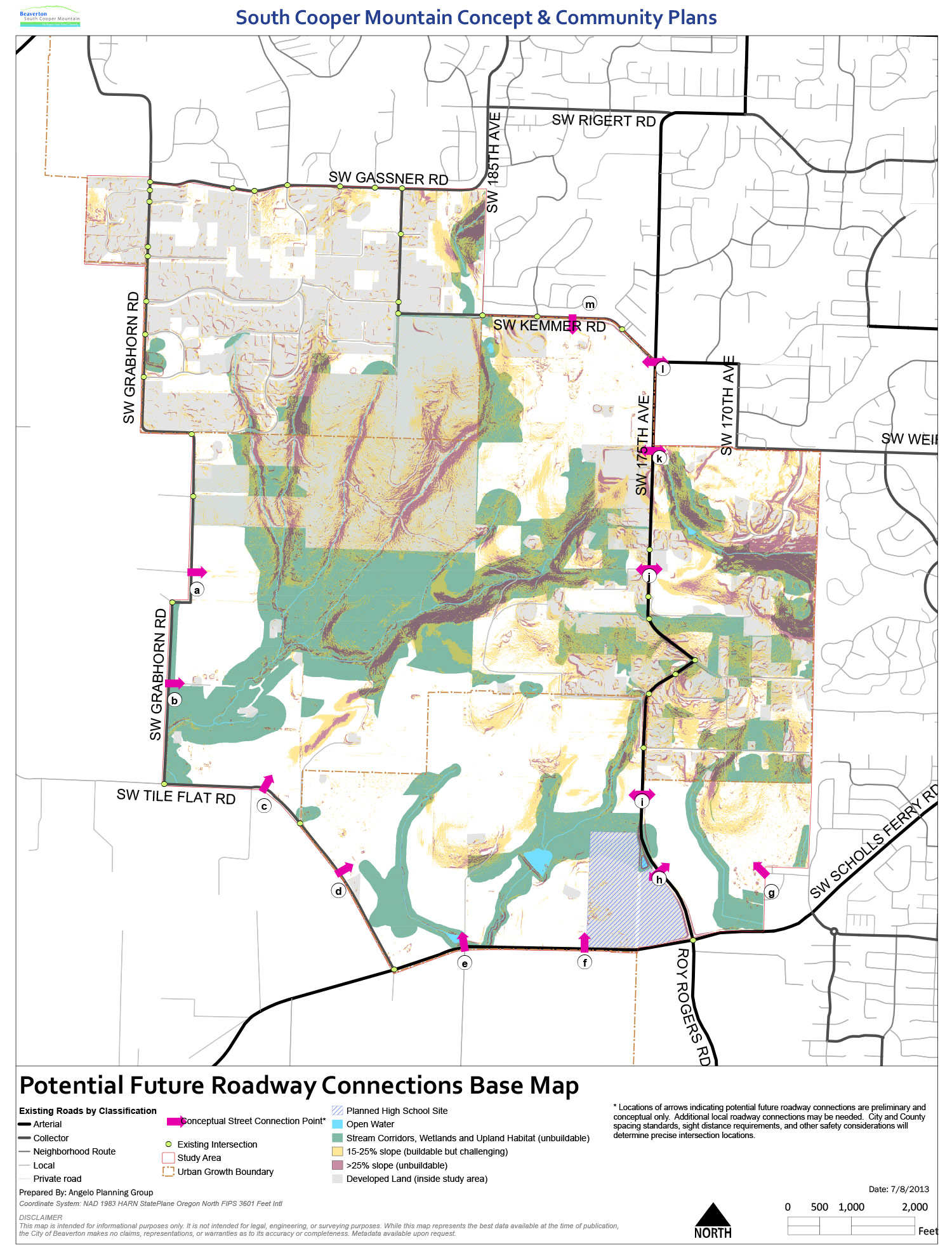
4. Connectivity Needs

A network of new streets will be planned to serve the Concept Plan area, creating a connected community and working within the constraints of natural resources, slopes, and roadway design best practices.  Approximate locations of potential points to connect to existing roads are shown on the map as pink arrows. A working assumption is that all streets will be two lanes (sizing will be tested during the Scenarios phase).

Select two pink arrows from the map which represent an important “point a to point b” connection, and imagine a conceptual road between them. Describe the starting and ending points for two roads below:

Priority Starting Point Ending Point
1.
2.

Why did you choose the connections that you did? What kinds of land uses might be appropriate at various locations along these streets? (Explain below.)

Exercise 3: The SCMAA - Concepts for a Complete and Sustainable Community

Instructions: On the following map, drag the icons to arrange the different land use types within the planning area. Each circle represents 100 housing units - click the icon to learn more about that particular type of land use.

Your challenge: Try to arrange all 39 icons so they don't overlap with each other, environmental constraints (noted in green), steep slopes (noted in red), or the new high school (noted in blue).

Review your answers, then click "Submit"

(Tip: You may return to any of the exercises to make changes before you click the submit button at the bottom of this page.)

Exercise 1 - You answered 0/6 land use questions.

Exercise 2 - You answered 0/6 transportation questions.

Exercise 3 - You placed 0/39 markers.

Please make sure that your name and email (if provided) are correct:

(Required.)


Live in North Cooper Mountain
Live in the Urban Reserve Area
Live in the S. Cooper Mtn Annexation Area
Live near the Planning Area
Own/represent property within the Planning Area (but don't live there)
Own/represent property near the Planning Area (but don't live there)
Work in or near the Planning Area
None of the above - just care about the area

Do you have any other comments to share?